


WESCAM MX-Series: The View that Changes Airborne Law Enforcement Outcomes
The call comes in just after sunset. As light fades and cloud cover thickens, a vehicle pursuit crosses county lines, causing ground units to lose sight of the suspect amid narrowing roads and congested traffic. Above the unfolding scene, a tactical flight officer utilizes a white-hot infrared sensor to maintain a steady track through trees, overpasses, and changing terrain, allowing deputies to reposition safely below while the pilot hovers at altitude.
Such moments epitomize the critical nature of airborne law enforcement.
In the realm of aviation units, electro-optical/infrared (EO/IR) technology has become a cornerstone of contemporary public safety operations. Whether it involves vehicle pursuits, missing person searches, perimeter security, or tactical overwatch, agencies heavily rely on imaging systems that deliver dependable performance every time aircraft are deployed.
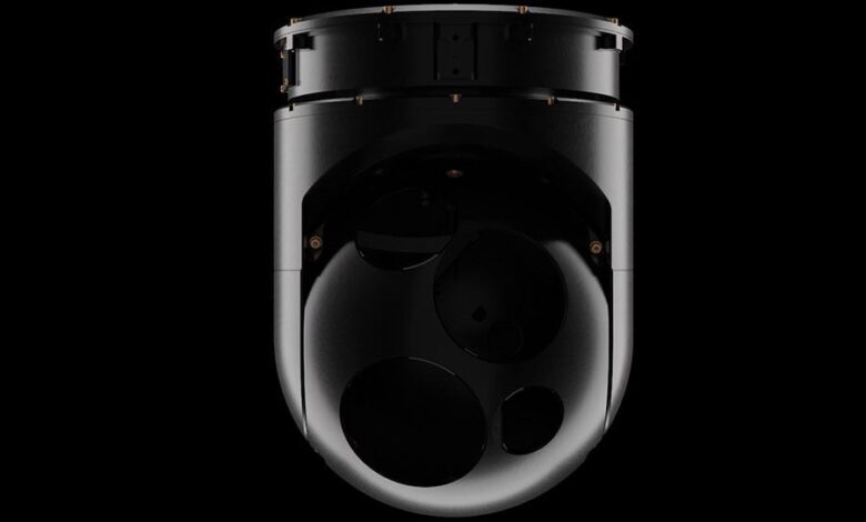
This trust underscores why airborne law enforcement operators consistently choose the L3Harris WESCAM MX-10 EO/IR sensor system during both day and night operations.
Engineered for the Mission
Specifically designed for airborne surveillance and reconnaissance missions, the WESCAM MX-10 integrates high-definition daylight imaging, advanced thermal sensors, and precise stabilization in a compact, lightweight package tailored for rotary-wing aircraft as well as unmanned platforms.
The system’s minimal size, weight, and power profile enable seamless integration across a diverse array of airborne platforms, enhancing aircraft performance and expanding mission flexibility. For agencies enhancing their airborne capabilities through unmanned systems, the WESCAM MX-10 provides sophisticated imaging abilities without compromising endurance or payload capacity.
Enhancing Operator Effectiveness
For tactical flight officers, image stability is a key determinant of mission success. The WESCAM MX-10 features active multi-axis stabilization, which maintains a clear, stable view during aggressive maneuvering, high-speed pursuits, and operations in turbulent environments. This technology allows operators to utilize L3Harris’ Automatic Video Tracker, enabling crews to follow vehicles, suspects, and persons of interest while reducing workload during fast-paced events, thereby allowing personnel to prioritize mission coordination and officer safety.

The sensor system’s high-performance optics and precise geo-location capabilities equip crews with accurate target coordinates that can be quickly communicated to responding ground units and dispatch centers. In the context of pursuits, search and rescue operations, or perimeter security missions, the ability to swiftly share actionable location information enhances both response times and operational coordination.
As operations transition from day to night, the MX-10’s advanced infrared imaging capabilities instill confidence in crews to continue functioning under varying environmental and lighting conditions. Whether tasked with locating a missing child in obscured terrain, supporting officers during foot pursuits, or conducting surveillance from altitude, operators maintain crucial situational awareness when it matters most.
Assured Reliability
Reliability is paramount in airborne operations. Air support units frequently operate under demanding flight schedules with little margin for error. Designed from technology proven in military and government operations worldwide, the WESCAM MX-10 meets the high operational availability demanded by agencies for their daily activities, year after year.
For organizations managing diverse fleets of helicopters and unmanned aircraft, the MX-Series common operator interface streamlines training, permitting crew members to transition smoothly between platforms. Its interoperability with modern mission management software, digital mapping applications, and public safety command and control systems further enhances situational awareness within the broader response network.

Sheriff and police aviation units throughout North America and Europe continuously rely on WESCAM MX-Series imaging systems to enhance their airborne missions. From major metropolitan law enforcement agencies operating dedicated helicopter fleets to regional organizations expanding into unmanned aircraft operations, crews depend on trusted sensor performance to support officers and the communities they serve.
The evolution of airborne law enforcement is also branching out beyond helicopters.
From Rotary to Unmanned Platforms
Public safety agencies are progressively adopting unmanned aircraft systems as part of their surveillance, reconnaissance, and disaster response operations. The compact size, weight, and power attributes of both the WESCAM MX-8 and MX-10 facilitate integration onto a widening array of UAV platforms, thereby extending persistent overwatch capability while simultaneously reducing operational costs and increasing deployment flexibility for agencies aiming to broaden aerial coverage without raising flight hours.
Whether deploying from a sheriff’s helicopter, a police aviation unit, or a next-generation unmanned aircraft, the core mission remains the same: locate the subject, maintain the track, support officers on the ground, and ensure community safety.
Source: L3Harris (2026-07-14)