

Maritime surveillance: How Airbus keeps our oceans safe
Oceans are essential not just as ecosystems but also as economic resources. However, their immense size, coupled with increasing maritime activities, complicates monitoring efforts by governments, coast guards, border patrols, and environmental agencies.
Airbus solutions are at the forefront of maritime surveillance, offering crucial support in efforts to safeguard our oceans. Whether on land, in the air, or from space, Airbus provides the necessary tools to enhance maritime oversight.
SPATIONAV: Monitoring the French Coastline
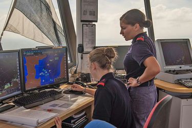
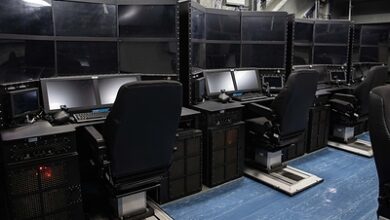
For over two decades, the French Navy has partnered with Airbus for maritime surveillance operations, anchored by the SPATIONAV system—a digital coastal surveillance tool providing French authorities with comprehensive maritime insights.
SPATIONAV integrates data from an extensive network of cameras, radars, and sensors positioned along the French coasts and overseas territories, including Mayotte and French Guiana. “The setup consists of 105 sites along the French coastline, covering 6,000 kilometres,” explains Nicolas L., Programme Officer for SPATIONAV at the French Navy.
Utilizing Airbus’ STYRIS solution, SPATIONAV amalgamates sensor data to track maritime routes and share critical risk assessments. “With SPATIONAV, we can observe ship movements at sea, receive vessel information like names, and assess risk levels,” said Nicolas L. “For instance, we can detect if a ship is traveling too fast, approaching restricted zones, or getting too close to another vessel.”
The ultimate goal is to enhance ocean safety: “SPATIONAV promptly alerts us of suspicious activities, including illegal immigration, drug trafficking, and illegal fishing. This solution aids in protecting marine conservation areas by identifying intruders and ensuring the security of our coasts.”
“Quick decision-making is vital in maritime surveillance,” noted Commander Nicolas L. and his team. “Depending on the scenario, swift decisions may involve alerting coast guards, deploying patrol aircraft, or launching search and rescue vessels.” Often, it can be as simple as alerting a vessel carrying hazardous cargo via voice communication. “As a real-time monitoring system, we rely on SPATIONAV for safeguarding the French coast,” he concluded.
C295: Tackling Pollution in Irish Waters
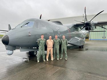
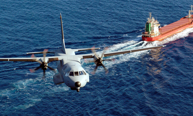
The Irish Air Corps is responsible for monitoring an expansive maritime area of over 132,000 square nautical miles. Since 2023, the Air Corps has operated two C295 aircraft in a maritime surveillance configuration (MSA) to enhance maritime defense and security, particularly within the Irish Exclusive Economic Zone (EEZ).
During a standard mission, the C295 conducts a six-hour patrol, primarily focused on fishery protection while also addressing pollution control. “When the Coast Guards receive satellite alerts regarding potential pollution, we are tasked with further investigation,” stated Donal Curran, 101 Squadron Commander and C295 pilot with the Irish Air Corps.
Additionally, the C295 is equipped with a Sea Pollution Detection System (SPDS), utilizing an infrared laser to scan the sea surface, thus minimizing manual monitoring efforts. “We can fly over the target zone, activate the SPDS, and cover approximately a 45-meter stretch depending on altitude. The system assesses both pollution depth and likely composition,” explained Commandant Curran.
This analysis is seamlessly integrated into the Fully Integrated Tactical System (FITS) reporting format for direct communication to the Irish Coast Guard, tasked with pollution oversight in local waters. “It’s been an invaluable tool; we’re receiving excellent feedback from the Coast Guards regarding its effectiveness,” mentioned Commandant Curran.
“Ireland is a small nation with limited defense resources. Maximizing our aircraft’s capabilities provides significant value to our state.” Donal Curran, 101 Squadron Commander and C295 pilot with the Irish Air Corps.
Getting the Full Picture from Space

Given the immense expanse of oceans, traditional ground and aerial surveillance methods may fall short. “Coastal radar or patrol vessels can only monitor limited areas,” notes Tim Pattison, Programme Manager at Airbus Defence and Space in the UK. “This presents challenges in effectively observing remote regions or extensive ocean stretches.”
This is where Airbus satellites play a crucial role in helping navies, coast guards, and other entities obtain a comprehensive view of the maritime environment. “In the UK, our current focus is on vessel detection,” Pattison elaborates. “We are enhancing our optical satellite constellation including Pléiades Neo and radar sensors such as TerraSAR-X and PAZ, along with data from partners like HawkEye360 for radio frequency details.” After pinpointing an area of interest, a tailored tasking plan is created, offering various options for data collection.
Targets detected via satellite imagery are cross-referenced with Automatic Identification System (AIS) data to verify vessel identification. Should AIS data be unavailable, these vessels are labeled as dark targets. “Our customers utilize this data for strategic planning, potentially dispatching patrol crafts or aircraft for further investigation,” Pattison clarified.
Satellite-based vessel monitoring serves diverse purposes, from combating illegal fishing and smuggling to enhancing marine protected area oversight. “A space-driven approach is essential for effective 24/7 maritime surveillance, providing our clients with a holistic view of sea activities,” Pattison added. More than just constant surveillance, this system enables customer adaptability and rapid scaling as needs fluctuate. “By integrating satellite data, we enhance clients’ flexibility allowing them to modify operational strategies without needing new infrastructure, streamlining overall mission effectiveness.”
Pattison and his team are committed to optimizing the process from satellite deployment to imagery delivery. “Timeliness in information is pivotal in maritime surveillance,” he stresses. Additionally, other innovative uses are under consideration, including automated oil spill and iceberg detection. The ultimate objective is to leverage satellite imagery in efforts to preserve and protect our oceans.
Source: Airbus Defence and Space (2024-07-01)